atmospheric front. Warm and cold front
It turned out that warm air is drawn into the cyclone not along its entire eastern (right) half, but in a rather limited sector located in the southern and southeastern parts of the cyclone between two convergence lines. Cloudiness and precipitation are unevenly distributed in the cyclone. Severe rains fall mainly in front of the first (eastern) line of convergence of air flows, as well as in the center of the cyclone. Heavy rains and thunderstorms are concentrated in a narrow band along the second (western) line of convergence. These lines were subsequently called atmospheric fronts. Since cyclones usually move from west to east in temperate latitudes, the eastern front of the cyclone first passes through the observation point, followed by warm air. This atmospheric front was called a warm front. In the vicinity of a warm atmospheric front, warm air actively advances on the front line, moves almost perpendicular to it, and cold air is transported almost parallel to this line, i.e. slowly back away from her. Consequently, the warm air mass catches up and overtakes the cold one. Then the western (cold) front of the cyclone approaches the observation point, during the passage of which the air temperature drops sharply. Near a cold atmospheric front, the dynamics are different: cold air catches up with warm air and rapidly displaces it upwards.
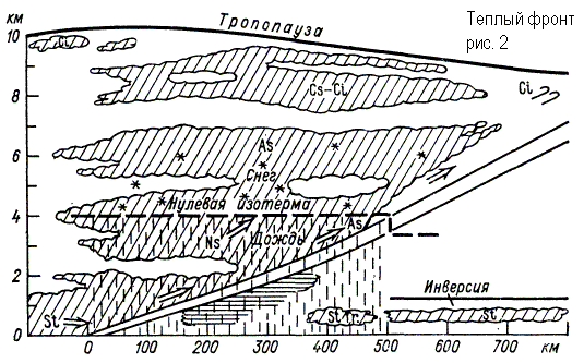
The upward sliding covers powerful layers of warm air over the entire frontal surface and an extensive system of highly stratified - nimbostratus clouds with extensive precipitation arises. A warm front has an anticyclonic curvature and moves towards colder air. On the weather map, a warm front is marked in red or as black semicircles directed in the direction of the front movement (Fig. 1). As the warm front line approaches, pressure begins to drop, clouds thicken, and heavy precipitation falls. In winter, when the front passes, low stratus clouds usually appear. The temperature and humidity of the air are slowly rising. When a front passes, temperature and humidity usually increase rapidly, and the wind increases. After the passage of the front, the direction of the wind changes (the wind turns clockwise), its speed decreases, the pressure drop stops and its weak growth begins, the clouds dissipate, precipitation stops. The field of baric tendencies is represented as follows: a closed area of pressure drop is located in front of the warm front, behind the front there is either an increase in pressure or a relative increase (a decrease, but less than in front of the front). The passage of a warm front is usually accompanied by a powerful nimbostratus cloud covering the entire sky with overcast rain. The first herald of a warm front is cirrus clouds. Gradually, they turn into a continuous white veil into cirrostratus clouds. Warm air is already moving in the upper atmosphere. The pressure drops. The closer the front line is to us, the denser the clouds become. The sun shines through with a dim spot. Then the clouds go down, the sun disappears completely. The wind intensifies and changes its direction clockwise (for example, at first it was east, then southeast and even southwest). Approximately 300-400 km before the front, the clouds thicken. Light rain or snow begins. But the warm front is over. The rain or snow has stopped, the clouds are dissipating, warming is setting in - a warmer air mass has come. A warm front in a vertical section is shown in fig. 2.
If the warm air recedes, and the cold spreads after it, then a cold front is approaching. His arrival always causes a cold snap. But when moving, not all layers of air have the same speed. The lowest layer, as a result of friction on the earth's surface, is slightly delayed, while the higher ones are pulled forward. Thus, cold air collapses on warm air in the form of a shaft. Warm air is quickly forced upward, and powerful piles of cumulus and cumulonimbus clouds are created. Cold front clouds carry showers, thunderstorms, accompanied by strong gusty winds. They can reach very high heights, but in the horizontal direction they extend only 20...30 km. And since the cold front usually moves quickly, the stormy weather does not last long - from 15 ... 20 minutes. up to 2 ... 3 hours. As a result of the interaction of cold air with a warm underlying surface, cumulus clouds with gaps are formed. Then comes complete clarity.
In the case of a cold front, the upward movement of warm air is limited to a narrower zone and is especially strong in front of a cold wedge, where warm air is displaced by cold air. The clouds here will largely have the character of cumulonimbus with showers and thunderstorms (Fig. 3, Fig. 4). The cold front has a cyclonic curvature (bulge towards warm air) and moves towards warm air. On the weather map, a cold front is marked in blue or with black triangles directed in the direction of the movement of the front (Fig. 1). The flow in cold air has a component directed towards the front line, so cold air, moving forward, occupies the space where warm air was before, which increases its instability.
When crossing the line of a warm front, the wind, as in the case of a warm front, turns to the right, but the turn is more significant and sharp - from the southwest, south (in front of the front) to the west, northwest (behind the front). This increases the wind speed. Atmospheric pressure ahead of the front changes slowly. It can fall, but it can also grow. With the passage of a cold front, a rapid increase in pressure begins. Behind the cold front there is a closed isallobaric region of pressure growth, and the growth can reach 3–5 hPa/3 h. A change in pressure in the direction of its growth (from a fall to an increase, from a slow increase to a stronger one) indicates the passage of a surface front line.
Thunderstorms and squalls are often observed ahead of the front. The air temperature after the passage of the front falls, and often quickly and sharply - by 10 ° C or more in 1-2 hours. The mass fraction of water vapor decreases simultaneously with air temperature. Visibility tends to improve as polar or arctic air enters behind the cold front. In addition, the instability of the air mass prevents condensation near the Earth's surface.
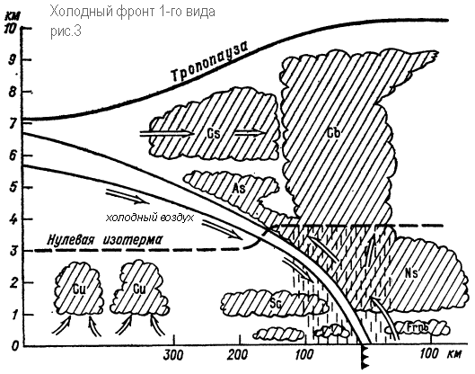
The nature of the weather on a cold front differs markedly depending on the speed of the front displacement, the properties of warm air in front of the front, and the nature of the ascending motions of warm air above the cold wedge. On cold fronts of the 1st kind, an ordered rise of warm air over a wedge of cold air prevails. The cold front of the 1st kind is a passive upward sliding surface. Slowly moving or decelerating fronts belong to this type, mainly on the periphery of cyclonic regions in deep baric troughs. In this case, the clouds are located mainly behind the front line. The difference from the cloudiness of the warm front still exists. Due to friction, the surface of the cold front in the lower layers becomes steep. Therefore, in front of the front line itself, instead of a calm and gentle upward sliding, a steeper (convective) rise of warm air is observed (Fig. 3). Due to this, powerful cumulus and cumulonimbus clouds sometimes appear in front of the cloud system, stretching for hundreds of kilometers along the front, with showers in summer, snowfalls in winter, thunderstorms, hail and squalls. Above the overlying part of the frontal surface with a normal inclination as a result of the upward sliding of warm air, the cloud system represents a uniform cover of stratus clouds. Showers before the front after the passage of the front are replaced by more uniform precipitation. Finally, cirrostratus and cirrus clouds appear. The vertical thickness of the system and the width of the cloud system and the precipitation area will be almost 2 times less than in the case of a warm front. The upper boundary of the system is approximately at an altitude of 4–4.5 km. Under the main cloud system, stratus broken clouds can occur, sometimes frontal fogs form. The duration of the passage of a cold front of the 1st kind through the observation point is 10 hours or more.
Fronts of the 2nd kind in the lower layer of the atmosphere are a passive surface of the upward sliding, and above - the active surface of the downward sliding. Most of the fast moving cold fronts in cyclones belong to this type. Here, the warm air of the lower layers is displaced upward by the cold shaft moving forward. The surface of the cold front in the lower layers is located very steeply, even forming a bulge in the form of a shaft (Fig. 4). The fast moving wedge of cold air causes forced convection of displaced warm air in a narrow space at the front of the frontal surface. A powerful convective flow is created here with the formation of cumulonimbus clouds, which intensifies as a result of thermal convection. The harbingers of the front are altocumulus lenticular clouds that spread in front of it at a distance of up to 200 km. The emerging cloud system has a small width (50-100 km) and is not a separate convective clouds, but a continuous chain, or a cloud bank, which sometimes may not be continuous. In the warm half of the year, the upper limit of cumulonimbus clouds extends to the height of the tropopause. On cold fronts of the 2nd kind, intense thunderstorm activity, showers, sometimes with hail, and squally winds are observed. There is heavy turbulence and icing in the clouds. The width of the zone of hazardous weather phenomena is several tens of kilometers. In the cold half of the year, the tops of cumulonimbus clouds reach 4 km. The snowfall zone is 50 km wide. This cloudiness is associated with heavy snowfalls, snowstorms with visibility less than 1000 m, a sharp increase in wind speed, and turbulence.

When cold fronts of the 2nd kind pass through the observation point, first (3-4 hours before the front line passes near the Earth) cirrus clouds appear, which are quickly replaced by high-stratus, sometimes lenticular, which are quickly replaced by a mass with showers, thunderstorms, hail, squalls. The duration of the movement of a cloud system with showers and thunderstorms usually does not exceed 1-2 hours. After the passage of the cold front, showers stop. A feature of cold fronts of both the first and second kind are prefrontal squalls. Since a steep inclination of the front surface is created in the front part of the cold wedge due to friction, part of the cold air is above the warm one. Then there is a “collapse” of cold air masses in front of the advancing cold shaft. Collapse of cold air leads to upward displacement of warm air and to the appearance of a vortex with a horizontal axis along the front. Squalls are especially intense on land in summer, when there is a large temperature difference between warm and cold air on both sides of the front, and when the warm air is unstable. Under these conditions, the passage of a cold front is accompanied by destructive wind speeds. The wind speed often exceeds 20-30 m/s, the duration of the phenomenon is usually several minutes, sometimes gusts are observed.
Fronts of occlusion
Due to downward movements in the cold air behind the cyclone, the cold front moves faster than the warm front and overtakes it over time. At the stage of cyclone filling, complex fronts arise - occlusion fronts, which are formed when cold and warm atmospheric fronts meet.

In the occlusion front system, three air masses interact, of which the warm one no longer comes into contact with the Earth's surface. The process of expelling warm air into the upper layers is called occlusion. In this case, the rear wedge of cold air of the cyclone merges with the front wedge of cold air. Warm air in the form of a funnel gradually rises, and its place is occupied by cold air coming from the sides (Fig. 5). The interface that occurs when the cold and warm fronts meet is called the occlusion front surface.
In the case of a cold front of occlusion, precipitation can fall on both sides of the lower front, and the transition from heavy precipitation to showers, if it occurs, occurs not ahead of the lower front, but in close proximity to it. In the case of a warm front of occlusion, the funnel of warm air is displaced by warmer air flowing onto a wedge of colder air. The rear wedge of less cold air catches up with the front wedge of colder air, and the cold front, having separated from the Earth's surface, rises along the surface of the warm front.
A weak upward sliding of the rear air along the forward air along the occlusion surface can lead to the formation of St-Sc-type clouds along it, which do not reach the level of ice cores. Of these, drizzling precipitation will fall in front of the lower warm front.
The lower part of the Earth's atmosphere, the troposphere, is in constant motion, shifting over the surface of the planet and mixing. Its individual sections have different temperatures. When such atmospheric zones meet, atmospheric fronts arise, which are boundary zones between air masses of different temperatures.
Formation of an atmospheric front
The circulation of tropospheric currents causes warm and cold air currents to meet. At the place of their meeting, due to the temperature difference, active condensation of water vapor occurs, which leads to the formation of powerful clouds, and subsequently to heavy precipitation.
The boundary of atmospheric fronts is rarely even, it is always tortuous and inhomogeneous, due to the fluidity of air masses. Warmer atmospheric currents flow on cold air masses and rise up, colder ones displace warm air, forcing it to rise higher.

Rice. 1. Approach of the atmospheric front.
Warm air is lighter than cold air and always rises, cold air, on the contrary, accumulates near the surface.
Active fronts move at an average speed of 30-35 km. per hour, but they can temporarily stop their movement. Compared with the volume of air masses, the boundary of their contact, which is called the atmospheric front, is very small. Its width can reach hundreds of kilometers. In length - depending on the magnitude of the colliding air currents, the front can be thousands of kilometers long.
Signs of a weather front
Depending on which atmospheric current moves more actively, warm and cold fronts are distinguished.
TOP 1 articlewho read along with this

Rice. 2. Synoptic map of atmospheric fronts.
Signs of an approaching warm front are:
- movement of warm air masses towards colder ones;
- formation of cirrus or stratus clouds;
- gradual weather change;
- drizzling or heavy rains;
- rise in temperature after the passage of the front.
The approach of a cold front is evidenced by:
- movement of cold air towards warm regions of the atmosphere;
- the formation of a large number of cumulus clouds;
- rapid weather changes;
- torrential and thunderstorms;
- subsequent decrease in temperature.
Cold air moves faster than warm air, so cold fronts are more active.
Weather and atmospheric front
In areas where atmospheric fronts pass, the weather changes.

Rice. 3. Collision of warm and cold air currents.
Its changes depend on:
- temperatures of the air masses encountered . The greater the temperature difference, the stronger the winds, the more intense the precipitation, the more powerful the clouds. And vice versa, if the temperature difference of air currents is small, then the atmospheric front will be weakly expressed and its passage over the Earth's surface will not bring any special weather changes;
- air current activity . Depending on their pressure, atmospheric flows can have different speeds of movement, on which the rate of weather change will depend;
- front shapes . The simpler linear forms of the front surface are more predictable. With the formation of atmospheric waves or the closure of individual outstanding tongues of air masses, vortices are formed - cyclones and anticyclones.
After the passage of a warm front, weather with a higher temperature sets in. After the passage of the cold - there is a cooling.
What have we learned?
Atmospheric fronts are border areas between air masses with different temperatures. The greater the temperature difference, the more intense the weather change will be during the passage of the front. The approach of a warm or cold front can be distinguished by the shape of the clouds and the type of precipitation.
Topic quiz
Report Evaluation
Average rating: 4.2. Total ratings received: 204.
If sometimes huge streams of warm and cold air currents come close to each other, then a clear dividing line can be drawn between them on a weather map, or, as meteorologists say, a front line.
It is with such fronts that inclement weather, heavy rains or snowfalls are directly connected.
The boundary between warm and cold air masses is the surface. This surface is almost horizontal and only slightly, completely imperceptibly, descends to the front line.
Cold air is under the frontal surface; it is shaped like an ax blade, and warm air is located above this surface. Where the frontal surface descends to the very ground, i.e. along the "axe blade", the front line passes.
Since air masses are constantly in motion, the boundary between them shifts either towards warm air, or towards cold air.
On any weather map, one very important and characteristic feature can be noted: a front line necessarily passes through the center of an area of low pressure, and, conversely, fronts never pass through the centers of areas of increased pressure.
WARM FRONT
If the front moves in the direction from warm air to cold air, i.e., cold air recedes, and warm air moves in after it, then such a front is called a warm front. It is this warm front that most often brings us the longest rains. When a warm front moves through some area, then warming sets in: a warm mass replaces the cold air mass.
Warm air moves faster than cold air, catches up with it, and it has to sort of "climb on the back" of the receding cold air. And the rise of air leads to its cooling; therefore, clouds form in the warm air above the frontal surface. Warm air climbs up very slowly and gradually, so the cloudiness of the warm front looks like an even, smooth veil of cirrostratus and altostratus clouds. This veil stretches along the front line in a wide strip several hundred meters wide and sometimes thousands of kilometers long. The farther ahead of the front line the clouds are, the higher they are above the Earth and the thinner they are. The highest clouds are called cirrus. They are located at an altitude of 7-9 km and consist of ice crystals.
Cirrostratus clouds also consist of ice crystals, but they are located somewhat lower and closer to the front. Altostratus clouds are even lower - at a height of 2-4 m and at a distance of 100-400 km from the front. Near the front there are nimbostratus clouds. Low broken clouds of "bad weather" rush over the earth at a height of only 100-200 m. They cover the tops of hills, the tops of radio masts and sometimes the tops of factory chimneys.
After the passage of the front, the wind changes its direction, and it always turns to the right. If before the front the wind blew from the southeast, then after the passage of the front it already blows from the south; if the wind was south, then it becomes south-west or west.
High transparent clouds moving 800-900 km ahead of the warm front line are those “messengers” sent ahead who warn us long before the onset of bad weather. It is by their appearance that it is possible to predict the beginning of rain in summer or snowfall in winter 10-14 hours in advance.
We have considered the formation of precipitation, which usually creates a long-term bad weather.
COLD FRONT
Often a clear day is replaced by a stormy downpour, a thunderstorm and a squall, followed by a cold snap. This weather is associated with a cold front. If warm air recedes and cold air spreads after it, then such a front is called a cold front. The arrival of this front always causes cooling, as the warm air mass is replaced by a cold one.

The lower part of the cold front, due to friction against the earth's surface, moves more slowly than the upper part and lags behind it. Therefore, at the top, the surface of the cold front "bulges" forward, the cold air in the "head" of the cold front collapses down, and the frontal surface takes the convex shape of a rolling shaft. This shaft moves faster than the receding warm air, catches up with it and violently displaces it straight up. A shaft of swirling dark clouds (cumulonimbus clouds) is formed with a downpour, thunderstorm and hail (in summer) or a snow squall and a snowstorm (in winter).
The strongest thunderstorms and squalls are always associated with a cold front.
WEATHER PREDICTION
Knowing the interconnection of weather phenomena and carefully observing its changes, it is possible to predict the onset of bad weather or the improvement of the weather. It is only necessary to remember that none of the signs of weather change can be used separately from other weather phenomena. One must always first clearly imagine everything that is happening at a given moment in the atmosphere, and only on the basis of this can weather changes be predicted.
Any severe weather deterioration is due to the arrival of cyclones and associated fronts that replace anticyclones, and their movement can only be tracked using special synoptic maps. Only some signs of approaching fronts and cyclones can be used for local weather prediction.
In summer, during good weather, a sign of a possible onset of bad weather will be a violation of the usual daily weather pattern, which is characterized by an increase in temperature during the day and a decrease in it at night, an increase in wind during the day and its weakening at night, the formation of cumulus clouds during the day, dew at night and the formation of morning fogs.
The approach of a warm front, and therefore a cyclone, is always indicated by nighttime warming. In a cyclone, the winds are usually stronger than in an anticyclone, so as the cyclone approaches, the wind increases noticeably. Too sharp in comparison with the past day, the strengthening of the wind during the day or its too slight weakening at night indicates the approach of a cyclone. The absence of dew and fog at night is also a sign of the approach of a cyclone. This is also indicated sometimes by the weak development of cumulus clouds during the day.
In winter, the daily course of weather phenomena is weakly expressed and the approaching cyclone usually makes itself felt by increasing wind and temperature.
All these signs, even if they are sharply expressed and observed simultaneously, still do not give confidence in the onset of bad weather. The surest signs of a near bad weather are the appearance of cirrus and cirrostratus clouds in the sky, which thicken in a certain - most often in the western - part of the horizon. At the same time, the wind should blow in such a way that if you stand with your back to it, then the thickening of the clouds should be on the left and somewhat ahead - where there should be low pressure.
Signs of the cessation of bad weather: a sharp cold snap during rain and snow; change in wind direction to northwest or north; change in the nature of precipitation; the transition of uniform, with continuous cloudiness, rain into showers that change sharply in strength, sometimes with thunderstorms and hail, continuous snowfall - into separate strong outbreaks of blizzards.
We considered the warm front of the cyclone. Now let's look at the cold front. We will analyze the features and external manifestations that allow yachting to prepare for its approach. Cold areas are called sections of the main front, moving towards a relatively warm air mass. Behind the cold front moving cold air mass. If the air flow is directed from a cold air mass to a warmer one, then such a front is called a cold front. The lagging of the lower layers of air from the upper ones under the influence of friction on the earth's surface leads to the fact that the upper layers collapse down and take the form of a rolling shaft. Displaced straight up warm air quickly rises and forms a ridge of dark clouds - cumulonimbus clouds. Depending on the speed of air movement, cold fronts of the first kind (the speed of movement is low) and the second kind are distinguished.
The structure of the cold front.
The structure of a cold front differs depending on whether it is moving fast or slow. For this reason, there are:
- a cold front of the first kind - a slowly moving one, in which clouds and precipitation are located mainly behind the front line, which makes it difficult for yachting to detect its approach;
- cold front of the second kind - fast moving, in which clouds and precipitation are located mainly in front of the front line.
A cold front of the second kind is observed in the central part of the cyclone, and the first kind - on its periphery.
Cold front of the first kind.
With a cold front of the first kind, masses of warm air are displaced by a wedge of cold air invading under it. Here the cloud character is a mirror image of cloud cover. Immediately ahead of the cold atmospheric front line, cumulonimbus clouds (CL) form, from which showers fall, accompanied by thunderstorms. The width of the zone of shower cloudiness is several tens of kilometers.
The M3-Az cloud system with extensive precipitation is located behind the cold front line. The width of the cloudy zone, its thickness and, accordingly, the width of the precipitation zone are approximately half that of the warm one. Thus, unlike a warm front, the cloudiness system of a cold front of the first kind does not allow yachtsmen to detect its approach in advance by clouds.
Cold front of the second kind.
A cold front of the second kind is distinguished by the fact that the rapid movement of the air shaft causes a rapid rise of the displaced warm air in front of the front line, and downward movements of air currents prevent the spread of the cloud system directly behind the front line. The emerging cloud system is basically a shaft of powerful clouds Cb. When they spread in small quantities, Cc, Ac and Sc can be formed, and below them, in the zone of heavy rainfall, broken cumulus bad weather is usually observed. At altitudes of 4-5 km, the ascending flow of adiabatically cooled moist air meets the descending flow of adiabatically heated dry air. As a result, an upper secondary front is formed, under which the cloud bank Cb is pulled forward. Its leading edge, which has the character of Az, can gradually separate into ridges of lenticular clouds Ac. These clouds are carried forward for 200 - 300 km and their detection is a reliable warning in yachting about the approach of a cold front of the second kind.

Behind the line of the cold atmospheric front, descending air movements are observed in the air mass, especially significant in the front part of the air wedge. Therefore, intramass clouds do not arise here. Soon after the passage of the cold front line, a rapid clearing occurs, up to a complete one; only after a few hours, when the downward motions die out and the frontal surface rises sufficiently, can convective clouds and showers characteristic of an unstable mass appear.
 Showers during the passage of a cold front of the second kind are short (from several minutes to 1 hour), since the width of the precipitation zone is small, and the movement speed is significant. In the shaft of cumulonimbus clouds, breaks or less developed cloudiness of the lower and middle tiers are sometimes found. Thunderstorm activity develops in some areas, which, having faded in some areas, may appear in neighboring ones.
The direction of the wind during the passage of cold fronts of both kinds changes in the same way as in the case of a warm one, but the turn to the right (in the northern hemisphere) at the moment of passage is more significant and sharp. At the same time, the wind speed increases sharply.
When a cold front approaches, there is a short, usually weak, but gradually accelerating pressure drop. Immediately after the passage, the pressure rises due to the replacement of warm air by cold air.
The air temperature after passing the cold front line decreases. The temperature jump depends on the nature of the changing masses.
Cold fronts of both types are characterized by pre-frontal squalls, which are especially dangerous phenomena for yachting. The air behind the cold front is characterized by a downward movement, which becomes especially intense in the front of the wedge, where friction creates a steep slope of the front surface. The air, falling down, seems to roll forward, like the caterpillars of a tank, and the speed of its advance in all cases turns out to be greater than the corresponding component of the speed of warm air in the lower layers. Collapse of cold air leads to upward displacement of warm air and to the appearance of a vortex with a horizontal axis; the phenomena of frontal squalls are connected with this vortex.
 Especially intense downward movement takes place in the head of cold air. Descending from a height of several kilometers, this air heats up adiabatically, and due to this, the temperature jump is smoothed out. In some cases, a secondary cold front arises inside the cold wedge, separating the heated air of the "head" from the air lying further and not captured to such an extent by the downward movement.
This second cold front goes several kilometers behind the eroded main one. During its passage, there is a jump in temperature, winds and squalls, but it does not have a cloud system. This phenomenon is called the bifurcation of the cold front. Yachtsmen must always keep this in mind and not relax after the passage of a cold front. Squalls without a visible cloud system can cause a lot of problems in yachting. As they say, he crept up unnoticed.
In baric troughs in the rear of the cyclone, secondary cold fronts usually form. They have a cloud system similar to that of a cold front of the second kind, however, the vertical extent of the clouds in them is less than the extent of the clouds of the main fronts. In some cases, there may be several troughs and secondary fronts.
Sedentary (stationary) are sections of the main front that do not undergo significant movement.
In a cyclone, a cold front moves somewhat faster than a warm one. Over time, they converge, and then merge, starting near the center of the cyclone. Such a front, formed as a result of the merger of cold and warm, is called an occlusion front (closed). But about this in.
At the warm front, warm air flows into the cold, located in the form of a wedge at the bottom. Ahead of the surface line, there is an area of pressure drop, which is due to the replacement of cold air with warm air. As the pressure drops, the wind increases, reaches its maximum speed before the passage of the front, then weakens. Winds of the southeast direction predominate ahead of the front, passing behind the front to the south and southwest.
The slow upward movement of warm air along the frontal surface leads to its adiabatic cooling and the formation of a cloud system and a large precipitation zone, the width of the cloud zone extends up to 600-700 km.
The slope of the frontal surface is observed within 1/100 to 1/200.
The main cloud system of the front is nimbostratus and highly stratified Ns-As clouds located in the lower and middle tiers (5-6 km). Their upper border is almost horizontal, and the lower one decreases from the front edge to the front line, where it reaches a height of about 100 m (in cold weather it can be lower). Above As-Ns are cirrostratus and cirrus clouds. Sometimes they merge with the underlying cloud system. But often the clouds of the upper tier are separated from the Ns-As system by a cloud layer. A zone of extensive precipitation is observed under the main cloud system. It lies in front of the surface front line and has a length along the normal from the front up to 400 km.
In the precipitation zone, low broken-rain clouds with a lower boundary of 50-100 m are formed, sometimes frontal fogs occur, and ice is observed at temperatures from 0 to -3.
In winter, with strong winds, the passage of the front is accompanied by strong snowstorms. In summer, separate pockets of cumulonimbus clouds with showers and thunderstorms can appear on a warm front. Most often they occur at night. Their development is explained by the strong nighttime cooling of the upper layer of the main frontal cloud system at a relatively constant temperature in the lower layers of the cloud. This leads to an increase in temperature gradients and to an increase in vertical currents, which lead to the formation of cumulonimbus clouds. They are usually masked by nimbostratus clouds, which makes it difficult to visually identify them. When approaching nimbostratus clouds, inside which cumulonimbus clouds are hidden, turbulence (turbulence) begins, increased electrization, which negatively affects the operation of instrumentation.
In winter, in the zone of negative temperatures of the warm front cloudiness, there is a danger of aircraft icing. The lower limit of icing is the zero isotherm. Heavy icing is observed in flight in the zone of supercooled rain. In the cold season, the warm front becomes aggravated and more often gives difficult weather conditions: low cloud cover, poor visibility in snowstorms, precipitation, fog, icing in precipitation, ice on the ground, electrification in the clouds.


