What are parallels and meridians? Lesson summary "Degree network on the globe and maps. Geographic latitude"
Globe and geographic Maps"entangled" in a kind of grid consisting of intersecting lines. These lines did not appear on the maps immediately, since in ancient times the maps resembled the simplest plans.
The globe and the planes of its section
The earth is a sphere slightly flattened at the poles. The sphere can be cut by planes in different directions. It can be cut, firstly, in the same way as an orange is divided into slices, and, secondly, in the same way as an orange is cut across the slices with a knife. With any method of dissecting the ball by planes, circles are obtained, the boundaries of which are circles. The diameter of the circles is greatest if the section planes pass through the center of the ball. The diameters of such circles are equal to the diameter of the sphere.
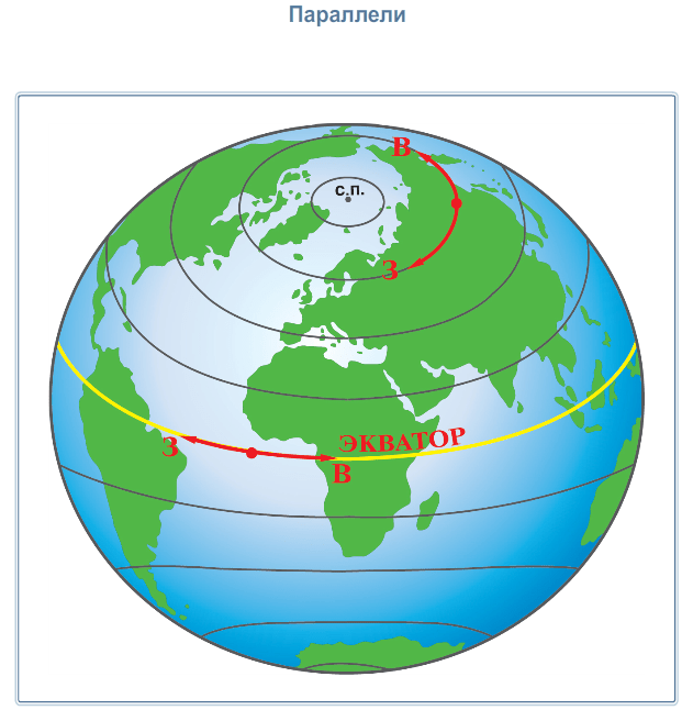
Let us turn to and mentally dissect the globe with planes perpendicular to the axis of rotation of the Earth. Circles parallel to each other appear on the surface of the globe. These circles are called parallels (from Greek word parallclos - walking beside). The longest and main parallel is the equator, its length is 40,076 kilometers.
The equator is equidistant from the poles of the planet and divides the Earth into Northern and Southern hemispheres. The length of other parallels decreases in the direction from the equator to the south and to the north. All points lying on the same parallel are equally distant from the equator. The lines of parallels show the west-east direction.
If you cut the globe with planes that pass through the axis of rotation of the Earth, then meridians will appear on the surface of the globe - semicircles connecting the North and South Poles of the Earth. They are perpendicular to the parallels and show the north-south direction. The word "meridian" itself means "midday" (from the Latin word meridianus), since the direction of all meridians coincides with the direction of the shadow from objects at noon.
All meridians have the same length - 20,005 kilometers. By agreement between the countries, the main, initial meridian is considered to be the meridian passing through the Greenwich Observatory in the suburbs of London. Therefore, this meridian is also called the Greenwich meridian. Greenwich meridian and its continuation on the opposite side
the globe divide the Earth into Western and Eastern hemispheres.

Parallels and meridians on maps
The parallels on the globe are circles, and the meridians are semicircles. But due to distortions, when the convex surface of the Earth is transferred to a plane, the image of these lines looks different. Whatever the form of the parallels and meridians, on any map, the directions to the east and west are determined only by the direction of the parallels, and to the north and south - only by the direction of the meridians. Thus, parallels and meridians allow you to navigate, that is, determine directions to the sides of the horizon.
Lines of parallels and meridians on the globe and maps can be drawn as many as you like. But only one meridian and one parallel passes through one point of the surface. The position of any point on a flat sheet can be characterized by two numbers of coordinates that show the position of this point relative to the edges of the sheet.
On a spherical surface, the coordinates of points are determined with respect to the equator and the prime meridian. To do this, use the system of parallels and meridians.
If our planet is “cut” through the axis of rotation and perpendicular to it by many planes, then vertical and horizontal circles will appear on the surface - meridians and parallels.
The meridians will converge at their ends at two points - at the North and South Poles. Parallels, as the name implies, are parallel to each other. Meridians are used to measure longitude, parallels - latitude.
Such a simple action at a superficial glance - the "line" of the Earth - has become greatest discovery in planetary exploration. It made it possible to use coordinates and accurately describe the location of any object. Without parallels and meridians, it is impossible to imagine any map, not a single globe. And they came up with ... in the III century BC, the Alexandrian scientist Eratosthenes.
Reference. Eratosthenes possessed encyclopedic knowledge for those times in all areas. He was in charge of the legendary Library of Alexandria, wrote the work "Geography" and became the founder of geography as a science, compiled the first map of the world and covered it with a degree grid of verticals and horizontals - he invented a coordinate system. He also introduced the names for the lines - parallel and meridian.
Meridian
Meridian in geography is called half of the line of section earth's surface drawn through and any point on the surface. All imaginary meridians, of which there can be an infinite number, are connected at the poles - North and South. The length of each of them is 20,004,276 meters.
Although you can mentally draw as many meridians as you like, for the convenience of movement, mapping their number, their location was streamlined by international treaties. In 1884, at the International Meridian Conference in Washington, it was decided that the initial meridian (zero) would be the one that passes through Greenwich, a district in southeast London.
However, not everyone immediately agreed with this decision. For example, in Russia, even after 1884 until the beginning of the 20th century, the zero meridian was considered to be its own - Pulkovo: it "passes" through the Round Hall of the Pulkovo Observatory.
Prime Meridian
The zero meridian is the reference point of geographic longitude. He, respectively, has a zero longitude. This was before the creation of the world's first satellite navigation system Transit. 
With its appearance, the zero meridian had to be slightly shifted - 5.3 "relative to Greenwich Mean. This is how the International Reference Meridian appeared, which is used as a longitude reference point by the International Earth Rotation Service.
Parallel
Parallels in geography are called lines of an imaginary section of the surface of the planet by planes that are parallel to the equatorial plane. The parallels depicted on the globe are circles parallel to the equator. They are used to measure latitude.
By analogy with the Greenwich zero meridian, there is also a zero parallel - this is the equator, one of the 5 main parallels that divides the Earth into hemispheres - southern and northern. Other main parallels are the tropics North and South, the polar circles - North and South.
Equator
The longest parallel is the equator - 40,075,696 m. The rotation speed of our planet at the equator is 465 m / s - this is much more than the speed of sound in air - 331 m / s.
Southern and Northern tropics
The Tropic of South, also called the Tropic of Capricorn, lies south of the equator and represents the latitude above which the noon sun is at its zenith on the day winter solstice.
The northern tropic, also known as the tropic of Cancer, is located north of the equator and, like the southern tropic, represents the latitude over which the midday sun is at its zenith on the summer solstice.
Arctic Circle and Antarctic Circle
The Arctic Circle is the boundary of the polar day area. To the north of it, in any place at least once a year, the sun is visible above the horizon 24 hours a day, or the same amount is not visible.
The southern polar circle is similar in everything to the northern one, only it is located in the southern hemisphere.
Graticule
The intersections of meridians and parallels form a degree grid. Meridians and parallels are spaced at intervals of 10° - 20°, smaller divisions, as in the corners, are called minutes and seconds. 
With the help of a degree grid, we determine the exact location of geographical objects - their geographical coordinates, calculating longitude by meridians, and latitude by parallels.
As a child, I could not understand why strange lines were drawn on the globe. With full confidence that I was right, I proved to my classmates that they were real. Once we even planned to go with the first - B class to look for them, but, thank God, our teacher explained to us what was happening. Why do we need non-existent stripes?
Let's figure it out.
Parallel - what is it
Strange stripes on the map mean nothing more than latitude and longitude. For example, let's imagine ourselves standing near a huge school globe. Personally, in our class, he had not only the designations of parallels and meridians, but also the signatures of all the hooligans of the school and the prints of children's hands. In general, not the point. The rod in the school globe is an imaginary planetary axis, which connects opposite poles. Also between them to be equator. On the globe, it is often indicated as a horizontal connection of our makeshift planet. Equatorial latitude is indicated by zero, and lines with an increasing index are located above and below. All parallels display their quantitative sign and are measured in degrees relative to the equator.
Meridians - designation of planetary longitude
And yet, latitude alone will not be enough for us. To find out the location of an object, we need to know the position of the point relative to other cardinal points. The meridian, marked zero, passes through the observatory at Greenwich and divides the Earth into two hemispheres - western and eastern. All longitudes also have their own numerical designation and are calculated in degrees relative to the Greenwich meridian. We have repeatedly seen on the maps that they do not intersect and unite only at the pole.
Let's summarize the information:
- strange stripes on the map indicate longitude or latitude;
- equator - latitude indicated by zero, divides the planet into North and South;
- the meridian, marked zero, passes through Greenwich and divides the Earth from West to East;
- axis - connects opposite poles.
Why do we need these strange stripes
It's simple - for orientation within the world. Any point on the planet is just the intersection of parallels and meridians, and thanks to this coordinate system, we have greatly facilitated our lives. For example, the work of pilots would be very complicated without the existence of parallels and meridians.
Knowing that our planet has a shape very close to the shape of a ball, and observing during travels in various places the apparent rotation of the Sun and stars, ancient scientists established certain conditional lines for orientation on the earth's surface.
Let's go on a mental journey on the surface of the Earth. The position above the horizon of the imaginary axis of the world, around which the firmament rotates daily, will change for us all the time. In accordance with this, the picture of the movement of the starry sky will also change. Going north, we will see that the stars in the southern part of the sky rise to a lower height each night. And the stars in the northern part - in the lower climax - have a greater height. Moving long enough, we'll hit North Pole. Not a single star rises or falls here at all. It will seem to us that the whole sky is slowly spinning parallel to the horizon.
Ancient travelers did not know that the apparent movement of the stars is a reflection of the rotation of the Earth. And they haven't been to the Pole. But it was necessary to have a reference point on the earth's surface. And they chose for this purpose a north-south line, easily identifiable by the stars. This line is called the meridian.
Meridians can be drawn through any point on the surface of the Earth. Many meridians form a system of imaginary lines connecting the North and South Poles of the Earth, which is convenient to use to determine the location.
Let's take one of the meridians as the initial one. The position of any other meridian in this case will be known if the reference direction is specified and the dihedral angle between the plane of the desired meridian and the plane of the initial meridian is given.
The position of the prime meridian has changed many times over the centuries. In 1493, immediately after the first voyage of Columbus to the shores of the West Indies, Pope Alexander VI divided the real world between Spain and Portugal. The border of the future possessions of the two greatest maritime powers dissected Atlantic Ocean from pole to pole. And when, decades later, it turned out that the contours of the lands of the New World and the distant borders of Asia, it turned out that all of America fell into the western, “Spanish” half of the globe, with the exception of its Brazilian ledge, and the eastern, “Portuguese” half was hit, in addition to Brazil , all of Africa and Asia.
Such a reference line of longitudes existed for about one hundred and fifty years. In 1634, under Cardinal Richelieu, a special commission of French scholars proposed to draw the prime meridian closer to Europe, but in such a way that the entire territory of Europe and Africa would be east of it. For this purpose, the zero meridian was drawn through the westernmost point of the Old World, the western tip of the westernmost of the archipelago canary islands- Island of Ferro. In 1884, at an astronomical conference in Washington, the reference meridian for the globe was taken to be the one that passes through the axis of one of the telescopes of the Greenwich Observatory. The Greenwich meridian remains the prime meridian to this day.
The angle formed by any meridian with the initial is called longitude. Longitude, for example, the meridian of Moscow 37? east of Greenwich.
To distinguish points lying on the same meridian from each other, it was necessary to introduce a second geographical coordinate - latitude. Latitude is the angle drawn in this place Earth's surface a plumb line forms with the plane of the equator.
The terms "longitude" and "latitude" have come down to us from ancient navigators who described the length and width mediterranean sea. The coordinate that corresponded to the measurements of the length of the Mediterranean Sea became longitude, and the one that corresponded to the width became the modern latitude.
Finding latitude, like determining the direction of the meridian, is closely related to the movement of stars. Already ancient astronomers proved that the height of the celestial pole above the horizon is equal to the latitude of the place.
Let's assume that the Earth has the shape of a regular ball, and cut it along one of the meridians, as shown in the figure. Let the person shown in the figure as a light figure stand at the North Pole. For him, the direction is up, i.e. the direction of the plumb line coincides with the axis of the world. The pole of the world is right above his head. The height of the celestial pole is here 90?.
Since the apparent rotation of stars around the axis of the world is a reflection of the real rotation of the Earth, then at any point on the Earth, as we already know, the direction of the axis of the world remains parallel to the direction of the axis of rotation of the Earth. The direction of the plumb line changes when moving from point to point.
Take, for example, another person. The direction of the axis of the world remained the same for him as for the first one. And the direction of the plumb line has changed. Therefore, the height of the celestial pole above the horizon here is not 90?, but much less.
From simple geometric considerations it is clear that the height of the celestial pole above the horizon is indeed equal to the latitude.
A line connecting points of equal latitude is called a parallel.
Meridians and parallels form the so-called system geographical coordinates. Every point on the earth's surface has a well-defined longitude and latitude. And vice versa, if the meal and longitude are known, then one parallel and one meridian can be built, at the intersection of which one single point will be obtained.
This video tutorial will be especially useful for those who want to independently get acquainted with the topic "Degree grid". During the lesson, you will be able to determine what a parallel, meridian and graticule. The teacher will explain in detail how you can determine the direction of the parallels and meridians on the map.
The direction of the meridian coincides with the direction of the shadow at noon. Meridian- a conditional line drawn on the surface of the Earth from one pole to another. The magnitude of the arc and circumference of the meridian is measured in degrees. All meridians are equal, intersect at the poles, have a north-south direction. The length of one degree of each meridian is 111 km (divide the circumference of the Earth by the number of degrees: 40,000: 360 = 111 km). Knowing this value, it is not difficult to determine the distance along the meridian. For example, the length of the arc along the meridian is 20 degrees. To find out this length in kilometers, you need 20 x 111 = 2220 km.
Meridians are usually labeled at the top or bottom of the map.
The countdown of the meridians starts from the zero meridian (0 degrees) - Greenwich.

Rice. 2. Meridians on the map of Russia
Parallel- a conditional line drawn along the surface of the Earth parallel to the equator. The direction of the parallel points to west and east. The parallels are drawn not only parallel to the equator, but also parallel to other parallels, they are different in length and do not intersect.
The longest parallel (40,000 km) is the equator (0 degrees).

Rice. 3. Equator on the map ()
The length of one degree of each parallel can be seen at the border of the map.
Length of 1 degree parallels ():


Rice. 4. Parallels (a) and meridians (b) ()
Parallels and meridians can be drawn through any place on the earth's surface. Parallels and meridians can be used to determine the main and intermediate sides of the horizon. The meridians determine the directions "north", "south", along the parallels - "east", "west". Intersecting, parallels and meridians form a degree network.
Homework
Paragraph 11.
1. Tell us about the grid.
Bibliography
Main
1. Initial course of geography: Proc. for 6 cells. general education institutions / T.P. Gerasimova, N.P. Neklyukov. - 10th ed., stereotype. - M.: Bustard, 2010. - 176 p.
2. Geography. Grade 6: atlas. - 3rd ed., stereotype. - M.: Bustard, DIK, 2011. - 32 p.
3. Geography. Grade 6: atlas. - 4th ed., stereotype. - M.: Bustard, DIK, 2013. - 32 p.
4. Geography. 6 cells: cont. cards. - M.: DIK, Bustard, 2012. - 16 p.
Encyclopedias, dictionaries, reference books and statistical collections
1. Geography. Modern illustrated encyclopedia / A.P. Gorkin. - M.: Rosmen-Press, 2006. - 624 p.
Literature for preparing for the GIA and the Unified State Examination
1. Geography: initial course. Tests. Proc. allowance for students 6 cells. - M.: Humanit. ed. center VLADOS, 2011. - 144 p.
2. Tests. Geography. 6-10 cells: Teaching aid/ A.A. Letyagin. - M .: LLC "Agency" KRPA "Olimp": "Astrel", "AST", 2001. - 284 p.
Materials on the Internet
1. Federal Institute pedagogical measurements ().
2. Russian Geographic Society ().