What is the scale in 1 cm 20 km. Scales of topographic maps and plans
The frames of maps of derived scales are built by dividing the base sheet along the lines of parallels and meridians into several equal parts, i.e. The layout of sheets is always built on a geographical coordinate grid. We consider the following scales of maps and plans to be standard:
Layout scheme and nomenclature of topographic maps of derived scales for the main Russian Federation coordinate systems SK-42:
| Scale |
base sheet |
broken down into |
Designation |
frame size |
| 1: 1 000 000
|
N-37 |
4 x 6 degrees |
||
| 1: 500 000
|
1: 1 000 000
|
4 sheets (A, B, C, D) |
N-37-B |
2 x 3 degrees |
| 1: 200 000
|
1: 1 000 000
|
36 sheets (I-XXXVI) |
N-37-XXIII |
40" x 60" |
| 1: 100 000
|
1: 1 000 000
|
144 sheets (1-144) |
N-37-89 |
20" x 30" |
| 1: 50 000
|
1: 100 000
|
4 sheets (A, B, C, D) |
N-37-44-B |
10" x 15" |
| 1: 25 000
|
1: 100 000
|
16 sheets (a, b, c, d) |
N-37-114-GB |
5" x 7" 30" |
| 1: 10 000
|
1: 100 000
|
64 sheets (1,2,3,4) |
N-37-78-Bv-3 |
2" 30" x 3" 45" |
Topographic maps of scale 1: 200,000 and smaller are open for us, for a scale of 1: 100,000 the order of use is determined - for official use, all larger scales of topographic maps are closed.
|
|
This figure shows the division of a sheet of scale 1: 1,000,000 On 4 sheets of scale 1: 500,000 (A, B, C, D), On 36 sheets of scale 1: 200,000 (indicated by Roman numerals), and On 144 sheets of scale 1: 100,000 (indicated by Arabic numerals). |
|
 |
This figure shows the division of a sheet of scale 1: 100,000: On 4 sheets of scale 1: 50,000 Scale sheet division 1: 50,000 Scale sheet division 1: 25,000 Three-digit numbers from 1 to 256 show the division into sheets at a scale of 1: 5,000, but maps of this scale are very rare in practice. |
|
|
|
|
|
Although the frames of all topographic maps have boundaries along a geographical grid, on the topographic map sheets themselves, starting from a scale of 1: 200,000 and for all maps larger, it is no longer a geographical, but a rectangular, so-called kilometer grid with a step of 4000 m for a scale of 1: 200,000 and up to 1000 m for a scale of 1: 10,000, which is a display of the Gauss-Kruger rectangular coordinate system.
On the standard topographic maps SK-42 there is full information about the coordinates of the sheet both in the geographic coordinate system and in the rectangular Gauss-Kruger coordinate system. The fragment of the topographic map below shows a corner with information about its coordinates and explains how to correctly understand it. This is a sheet of a topographic map at a scale of 1: 200,000 with item number N-38-XXII, made in the SK-42 coordinate system.
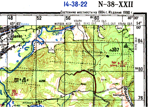 |
| The angle of the topographic map at a scale of 1: 200,000 and information about the coordinates: |
| at the very corner of the sheet are written geographical coordinates this angle, 46° 00" East and 54° 00" North; At the top frame, the numbers 48, 52, 56, 60 are the coordinates of the kilometer grid, and together with the small number 85 next to 60, they show the exact value of the Y coordinate of this vertical line in the Gauss-Kruger rectangular coordinate system, equal to 8,560,000 m; that is, this map is from zone 8, and the line coordinate is 60 km east of the middle meridian of the zone; At the right frame, the numbers 76, 80, 84 are also the coordinates of the kilometer grid, and together with the small number 59 next to 80 they show the exact value of the X coordinate of this horizontal line in the Gauss-Kruger rectangular coordinate system, equal to 5,980,000 m; is the distance to this line from the equator. |
Each card has scale- a number that shows how many centimeters on the ground correspond to one centimeter on the map.
map scale usually listed on it. Record 1: 100,000,000 means that if the distance between two points on the map is 1 cm, then the distance between the corresponding points on its terrain is 100,000,000 cm.
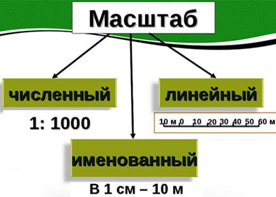
May be listed in numerical form as a fraction– numerical scale (for example, 1: 200,000). And it can be marked in linear form: as a simple line or strip divided into units of length (usually kilometers or miles).
The larger the scale of the map, the more detailed the elements of its content can be depicted on it, and vice versa, the smaller the scale, the more extensive space can be shown on the map sheet, but the terrain on it is depicted with less detail.
Scale is a fraction whose numerator is one. To determine which of the scales is larger and by how many times, let's recall the rule for comparing fractions with the same numerators: of two fractions with the same numerators, the one with the smaller denominator is larger.
The ratio of the distance on the map (in centimeters) to the corresponding distance on the ground (in centimeters) is equal to the scale of the map.
How does this knowledge help us in solving problems in mathematics?
Example 1
Let's look at two cards. A distance of 900 km between points A and B corresponds on one map to a distance of 3 cm. A distance of 1,500 km between points C and D corresponds to a distance of 5 cm on another map. Let us prove that the scales of the maps are the same.
Solution.
Find the scale of each map.
900 km = 90,000,000 cm;
the scale of the first map is: 3: 90,000,000 = 1: 30,000,000.
1500 km = 150,000,000 cm;
the scale of the second map is: 5: 150,000,000 = 1: 30,000,000.
Answer. The scales of the maps are the same, i.e. are equal to 1:30,000,000.
Example 2
The scale of the map is 1: 1,000,000. Let's find the distance between points A and B on the ground, if on the map
AB = 3.42 cm?
Solution.
Let's make an equation: the ratio of AB \u003d 3.42 cm on the map to the unknown distance x (in centimeters) is equal to the ratio between the same points A and B on the ground to the map scale:
3.42: x = 1: 1,000,000;
x 1 \u003d 3.42 1,000,000;
x \u003d 3,420,000 cm \u003d 34.2 km.
Answer: the distance between points A and B on the ground is 34.2 km.
 Example 3
The scale of the map is 1: 1,000,000. The distance between points on the ground is 38.4 km. What is the distance between these points on the map?
Solution.
The ratio of the unknown distance x between points A and B on the map to the distance in centimeters between the same points A and B on the ground is equal to the scale of the map.
38.4 km = 3,840,000 cm;
x: 3,840,000 = 1: 1,000,000;
x \u003d 3,840,000 1: 1,000,000 \u003d 3.84.
Answer: the distance between points A and B on the map is 3.84 cm.
Do you have any questions? Don't know how to solve problems?
To get the help of a tutor - register.
The first lesson is free!
site, with full or partial copying of the material, a link to the source is required.
INTRODUCTION
The topographic map is reduced a generalized image of the area, showing the elements using a system of conventional signs.
In accordance with the requirements, topographic maps are highly geometric accuracy and geographic fit. This is provided by their scale, geodetic base, cartographic projections and a system of symbols.
The geometric properties of a cartographic image: the size and shape of areas occupied by geographical objects, the distances between individual points, directions from one to another - are determined by its mathematical basis. Mathematical basis cards include as constituent parts scale, a geodesic base, and a map projection.
What is the scale of the map, what types of scales are there, how to build a graphical scale and how to use the scales will be considered in the lecture.
6.1. TYPES OF SCALE OF TOPOGRAPHIC MAP
When compiling maps and plans, horizontal projections of segments are depicted on paper in a reduced form. The degree of such a decrease is characterized by scale.
map scale (plan) - the ratio of the length of the line on the map (plan) to the length of the horizontal laying of the corresponding terrain line
m = l K : d M
The scale of the image of small areas on the entire topographic map is practically constant. At small angles of inclination of the physical surface (on the plain), the length of the horizontal projection of the line differs very little from the length of the inclined line. In these cases, the length scale can be considered as the ratio of the length of the line on the map to the length of the corresponding line on the ground.
The scale is indicated on the maps in different options
6.1.1. Numerical scale
Numerical scale expressed as a fraction with a numerator equal to 1(aliquot fraction).
Or
Denominator M the numerical scale shows the degree of reduction in the lengths of the lines on the map (plan) in relation to the lengths of the corresponding lines on the ground. Comparing numerical scales, the largest is the one whose denominator is smaller.
Using the numerical scale of the map (plan), you can determine the horizontal distance dm lines on the ground
Example.
Map scale 1:50 000. The length of the segment on the map lk\u003d 4.0 cm. Determine the horizontal location of the line on the ground.
Solution.
Multiplying the value of the segment on the map in centimeters by the denominator of the numerical scale, we get the horizontal distance in centimeters.
d\u003d 4.0 cm × 50,000 \u003d 200,000 cm, or 2,000 m, or 2 km.
note to the fact that the numerical scale is an abstract quantity that does not have specific units of measurement. If the numerator of a fraction is expressed in centimeters, then the denominator will have the same units of measurement, i.e. centimeters.
For example, a scale of 1:25,000 means that 1 centimeter of the map corresponds to 25,000 centimeters of terrain, or 1 inch of the map corresponds to 25,000 inches of terrain.
To meet the needs of the economy, science and defense of the country, maps of various scales are needed. For state topographic maps, forest management tablets, forestry plans and forest plantations, standard scales are defined - scale range(Tables 6.1, 6.2).
Scale series of topographic maps
Table 6.1.
| Numerical scale |
Map name |
1 cm card corresponds |
1 cm2 card corresponds |
|---|---|---|---|
five thousandth |
0.25 hectare |
||
ten thousandth |
|||
twenty-five thousandth |
6.25 hectares |
||
fifty thousandth |
|||
hundred thousandth |
|||
two hundred thousandth |
|||
five hundred thousandth |
|||
millionth |
Previously, this series included scales of 1:300,000 and 1:2,000.
6.1.2. Named Scalenamed scale
called the verbal expression of the numerical scale. Under the numerical scale on the topographic map there is an inscription explaining how many meters or kilometers on the ground corresponds to one centimeter of the map.
For example, on the map under a numerical scale of 1:50,000 it is written: "in 1 centimeter 500 meters." The number 500 in this example is named scale value
.
Using a named map scale, you can determine the horizontal distance dm lines on the ground. To do this, it is necessary to multiply the value of the segment, measured on the map in centimeters, by the value of the named scale.
Example. The named scale of the map is "2 kilometers in 1 centimeter". The length of the segment on the map lk\u003d 6.3 cm. Determine the horizontal location of the line on the ground.
Solution. Multiplying the value of the segment measured on the map in centimeters by the value of the named scale, we obtain the horizontal distance in kilometers on the ground.
d= 6.3 cm × 2 = 12.6 km.
To avoid mathematical calculations and speed up work on the map, use graphic scales . There are two such scales: linear and transverse .
Linear scaleTo build a linear scale, choose an initial segment that is convenient for a given scale. This original segment ( a) are called scale base (Fig. 6.1).

Rice. 6.1. Linear scale. Measured segment on the ground
will be CD = ED + CE = 1000 m + 200 m = 1200 m.
The base is laid on a straight line the required number of times, the leftmost base is divided into parts (segment b), to be the smallest divisions of the linear scale
. The distance on the ground that corresponds to the smallest division of the linear scale is called linear scale accuracy
.
How to use a linear scale:
- put the right leg of the compass on one of the divisions to the right of zero, and the left leg on the left base;
- the length of the line consists of two counts: a count of whole bases and a count of divisions of the left base (Fig. 6.1).
- If the segment on the map is longer than the constructed linear scale, then it is measured in parts.
Cross scale
For more accurate measurements, use transverse scale (Fig. 6.2, b).

Fig 6.2. Cross scale. Measured distance
PK =
TK +
PS +
ST =
1
00 +10
+ 7
=
117
m.
To build it on a straight line segment, several scale bases are laid ( a). Usually the length of the base is 2 cm or 1 cm. Perpendiculars to the line are set at the points obtained. AB and draw through them ten parallel lines at regular intervals. The leftmost base from above and below is divided into 10 equal segments and connected by oblique lines. The zero point of the lower base is connected to the first point FROM top base and so on. Get a series of parallel inclined lines, which are called transversals.
The smallest division of the transverse scale is equal to the segment C 1
D 1
,
(fig. 6. 2, a). The adjacent parallel segment differs by this length when moving up the transversal 0C and vertical line 0D.
A transverse scale with a base of 2 cm is called normal
. If the base of the transverse scale is divided into ten parts, then it is called hundreds
. On a hundredth scale, the price of the smallest division is equal to one hundredth of the base.
The transverse scale is engraved on metal rulers, which are called scale.
How to use the transverse scale:
- fix the length of the line on the map with a measuring compass;
- put the right leg of the compass on an integer division of the base, and the left leg on any transversal, while both legs of the compass should be located on a line parallel to the line AB;
- the length of the line consists of three counts: a count of integer bases, plus a count of divisions of the left base, plus a count of divisions up the transversal.
The accuracy of measuring the length of a line using a transverse scale is estimated at half the price of its smallest division.
6.2. VARIETY OF GRAPHIC SCALE
6.2.1. transitional scaleSometimes in practice it is necessary to use a map or an aerial photograph, the scale of which is not standard. For example, 1:17 500, i.e. 1 cm on the map corresponds to 175 m on the ground. If you build a linear scale with a base of 2 cm, then the smallest division of the linear scale will be 35 m. Digitization of such a scale causes difficulties in the production of practical work.
To simplify the determination of distances on a topographic map, proceed as follows. The base of a linear scale is not taken to be 2 cm, but calculated so that it corresponds to a round number of meters - 100, 200, etc.
Example. It is required to calculate the length of the base corresponding to 400 m for a map at a scale of 1:17,500 (175 meters in one centimeter).
To determine what dimensions a segment of 400 m long will have on a 1:17,500 scale map, we draw up the proportions:
on the ground on the plan
175 m 1 cm
400 m X cm
X cm = 400 m × 1 cm / 175 m = 2.29 cm.
Having solved the proportion, we conclude: the base of the transitional scale in centimeters is equal to the value of the segment on the ground in meters divided by the value of the named scale in meters. The length of the base in our case
a= 400 / 175 = 2.29 cm.
If we now construct a transverse scale with a base length a\u003d 2.29 cm, then one division of the left base will correspond to 40 m (Fig. 6.3).

Rice. 6.3. Transitional linear scale.
Measured distance AC \u003d BC + AB \u003d 800 +160 \u003d 960 m.
For more accurate measurements on maps and plans, a transverse transitional scale is built.
6.2.2. Step scaleUse this scale to determine the distances measured in steps during eye survey. The principle of constructing and using the scale of steps is similar to the transitional scale. The base of the scale of steps is calculated so that it corresponds to the round number of steps (pairs, triplets) - 10, 50, 100, 500.
To calculate the value of the base of the steps scale, it is necessary to determine the survey scale and calculate the average step length Shsr.
The average step length (pairs of steps) is calculated from the known distance traveled in the forward and backward directions. By dividing the known distance by the number of steps taken, the average length of one step is obtained. When tilted earth's surface the number of steps taken in the forward and reverse directions will be different. When moving in the direction of increasing relief, the step will be shorter, and in reverse side- longer.
Example. A known distance of 100 m is measured in steps. There are 137 steps in the forward direction and 139 steps in the reverse direction. Calculate the average length of one step.
Solution. Total covered: Σ m = 100 m + 100 m = 200 m. The sum of the steps is: Σ w = 137 w + 139 w = 276 w. The average length of one step is:
Shsr= 200 / 276 = 0.72 m.
It is convenient to work with a linear scale when the scale line is marked every 1 - 3 cm, and the divisions are signed with a round number (10, 20, 50, 100). Obviously, the value of one step of 0.72 m on any scale will have extremely small values. For a scale of 1: 2,000, the segment on the plan will be 0.72 / 2,000 \u003d 0.00036 m or 0.036 cm. Ten steps, on the appropriate scale, will be expressed as a segment of 0.36 cm. The most convenient basis for these conditions, according to the author, there will be a value of 50 steps: 0.036 × 50 = 1.8 cm.
For those who count steps in pairs, a convenient base would be 20 pairs of steps (40 steps) 0.036 × 40 = 1.44 cm.
The length of the base of the steps scale can also be calculated from proportions or by the formula
a = (Shsr × KSh) / M
where: Shsr - average value of one step in centimeters,
KSh - number of steps at the base of the scale ,
M - scale denominator.
The length of the base for 50 steps on a scale of 1:2,000 with a step length of 72 cm will be:
a= 72 × 50 / 2000 = 1.8 cm.
To build the scale of steps for the above example, it is necessary to divide the horizontal line into segments equal to 1.8 cm, and divide the left base into 5 or 10 equal parts.

Rice. 6.4. Step scale.
Measured distance AC \u003d BC + AB \u003d 100 + 20 \u003d 120 sh.
6.3. SCALE ACCURACY
Scale Accuracy
(maximum scale accuracy) is a segment of the horizontal line, corresponding to 0.1 mm on the plan. The value of 0.1 mm for determining the accuracy of the scale is adopted due to the fact that this is the minimum segment that a person can distinguish with the naked eye.
For example, for a scale of 1:10,000, the scale accuracy will be 1 m. In this scale, 1 cm on the plan corresponds to 10,000 cm (100 m) on the ground, 1 mm - 1,000 cm (10 m), 0.1 mm - 100 cm (1m). From the above example, it follows that if the denominator of the numerical scale is divided by 10,000, then we get the maximum scale accuracy in meters.
For example, for a numerical scale of 1:5,000, the maximum scale accuracy will be 5,000 / 10,000 =
0.5 m
Scale accuracy allows you to solve two important tasks:
- definition minimum dimensions objects and objects of the area that are depicted on a given scale, and the sizes of objects that cannot be depicted on a given scale;
- setting the scale at which the map should be created so that it depicts objects and terrain objects with predetermined minimum sizes.
In practice, it is accepted that the length of a segment on a plan or map can be estimated with an accuracy of 0.2 mm. The horizontal distance on the ground, corresponding to a given scale of 0.2 mm (0.02 cm) on the plan, is called graphic accuracy of scale
. Graphical accuracy of determining distances on a plan or map can only be achieved using a transverse scale..
It should be borne in mind that when measuring the relative position of the contours on the map, the accuracy is determined not by the graphical accuracy, but by the accuracy of the map itself, where errors can average 0.5 mm due to the influence of errors other than graphical ones.
If we take into account the error of the map itself and the measurement error on the map, then we can conclude that the graphical accuracy of determining distances on the map is 5–7 worse than the maximum scale accuracy, i.e., it is 0.5–0.7 mm on the map scale.
6.4. DETERMINATION OF UNKNOWN MAP SCALE
In cases where for some reason the scale on the map is missing (for example, cut off when gluing), it can be determined in one of the following ways.
- On the grid . It is necessary to measure the distance on the map between the lines of the coordinate grid and determine how many kilometers these lines are drawn through; This will determine the scale of the map.
For example, the coordinate lines are indicated by the numbers 28, 30, 32, etc. (along the western frame) and 06, 08, 10 (along the southern frame). It is clear that the lines are drawn through 2 km. The distance on the map between adjacent lines is 2 cm. It follows that 2 cm on the map corresponds to 2 km on the ground, and 1 cm on the map corresponds to 1 km on the ground (named scale). This means that the scale of the map will be 1:100,000 (1 kilometer in 1 centimeter).
- According to the nomenclature of the map sheet. The notation system (nomenclature) of map sheets for each scale is quite definite, therefore, knowing the notation system, it is easy to find out the scale of the map.
A map sheet at a scale of 1:1,000,000 (millionth) is indicated by one of the letters Latin alphabet and one of the numbers from 1 to 60. The notation system for maps of larger scales is based on the nomenclature of sheets of a millionth map and can be represented by the following scheme:
1:1 000 000 - N-37
1:500 000 - N-37-B
1:200 000 - N-37-X
1:100 000 - N-37-117
1:50 000 - N-37-117-A
1:25 000 - N-37-117-A-g
Depending on the location of the map sheet, the letters and numbers that make up its nomenclature will be different, but the order and number of letters and numbers in the nomenclature of a map sheet of a given scale will always be the same.
Thus, if a map has the M-35-96 nomenclature, then by comparing it with the above diagram, we can immediately say that the scale of this map will be 1:100,000.
See Chapter 8 for details on card nomenclature.
- By distances between local objects. If there are two objects on the map, the distance between which on the ground is known or can be measured, then to determine the scale, you need to divide the number of meters between these objects on the ground by the number of centimeters between the images of these objects on the map. As a result, we get the number of meters in 1 cm of this map (named scale).
For example, it is known that the distance from n.p. Kuvechino to the lake. Deep 5 km. Having measured this distance on the map, we got 4.8 cm. Then
5000 m / 4.8 cm = 1042 m in one centimeter.
Maps on a scale of 1:104 200 are not published, so we make rounding. After rounding, we will have: 1 cm of the map corresponds to 1,000 m of terrain, i.e., the map scale is 1:100,000.
If there is a road with kilometer posts on the map, then it is most convenient to determine the scale by the distance between them.
- According to the length of the arc of one minute of the meridian . Frames of topographic maps along the meridians and parallels have divisions in minutes of the meridian and parallel arcs.
One minute of the meridian arc (along the eastern or western frame) corresponds to a distance of 1852 m (nautical mile) on the ground. Knowing this, it is possible to determine the scale of the map in the same way as by the known distance between two terrain objects.
For example, the minute segment along the meridian on the map is 1.8 cm. Therefore, 1 cm on the map will be 1852: 1.8 = 1,030 m. After rounding, we get a map scale of 1:100,000.
In our calculations, approximate values of the scales were obtained. This happened due to the approximation of the distances taken and the inaccuracy of their measurement on the map.
6.5. TECHNIQUE FOR MEASURING AND PUTTING DISTANCES ON A MAP
To measure distances on a map, a millimeter or scale ruler, a compass-meter is used, and a curvimeter is used to measure curved lines.
6.5.1. Measuring distances with a millimeter ruler
Use a millimeter ruler to measure the distance between given points on the map with an accuracy of 0.1 cm. Multiply the resulting number of centimeters by the value of the named scale. For flat terrain, the result will correspond to the distance on the ground in meters or kilometers.
Example. On a map of scale 1: 50,000 (in 1 cm - 500 m) the distance between two points is 3.4 cm.
Determine the distance between these points.
Solution. Named scale: in 1 cm 500 m. The distance on the ground between the points will be 3.4 × 500 = 1700 m.
At angles of inclination of the earth's surface more than 10º, it is necessary to introduce an appropriate correction (see below).
6.5.2. Measuring distances with a compass
When measuring distance in a straight line, the needles of the compass are set at the end points, then, without changing the solution of the compass, the distance is read off on a linear or transverse scale. In the case when the opening of the compass exceeds the length of the linear or transverse scale, the integer number of kilometers is determined by the squares of the coordinate grid, and the remainder - by the usual scale order.

Rice. 6.5. Measuring distances with a compass-meter on a linear scale.
To get the length broken line
sequentially measure the length of each of its links, and then summarize their values. Such lines are also measured by increasing the compass solution.
Example. To measure the length of a polyline ABCD(Fig. 6.6, a), the legs of the compass are first placed at points BUT and AT. Then, rotating the compass around the point AT. move the back leg from the point BUT exactly AT" lying on the continuation of the line sun.
Front leg from point AT transferred to a point FROM. The result is a solution of the compass B "C"=AB+sun. Moving the back leg of the compass in the same way from the point AT" exactly FROM", and the front of FROM in D. get a solution of the compass
C "D \u003d B" C + CD, the length of which is determined using a transverse or linear scale.

Rice. 6.6. Line length measurement: a - broken line ABCD; b - curve A 1 B 1 C 1;
B"C" - auxiliary points
Long curves measured along the chords with compass steps (see Fig. 6.6, b). The step of the compass, equal to an integer number of hundreds or tens of meters, is set using a transverse or linear scale. When rearranging the legs of the compass along the measured line in the directions shown in fig. 6.6, b arrows, count the steps. The total length of the line A 1 C 1 is made up of the segment A 1 B 1, equal to step multiplied by the number of steps, and the remainder B 1 C 1 measured on a transverse or linear scale.
6.5.3. Measuring distances with a curvimeter
Curved segments are measured with a mechanical (Fig. 6.7) or electronic (Fig. 6.8) curvimeter.
Rice. 6.7. Curvimeter mechanical
First, turning the wheel by hand, set the arrow to zero division, then roll the wheel along the measured line. The reading on the dial against the end of the arrow (in centimeters) is multiplied by the scale of the map and the distance on the ground is obtained. A digital curvimeter (Fig. 6.7.) is a high-precision, easy-to-use device. Curvimeter includes architectural and engineering functions and has a convenient display for reading information. This unit can process metric and Anglo-American (feet, inches, etc.) values, allowing you to work with any maps and drawings. You can enter the most commonly used type of measurement and the instrument will automatically translate scale measurements.

Rice. 6.8. Curvimeter digital (electronic)
To improve the accuracy and reliability of the results, it is recommended that all measurements be carried out twice - in the forward and reverse directions. In case of insignificant differences in the measured data, the average is taken as the final result arithmetic value measured values.
The accuracy of measuring distances by these methods using a linear scale is 0.5 - 1.0 mm on a map scale. The same, but using a transverse scale is 0.2 - 0.3 mm per 10 cm of line length.
6.5.4. Converting horizontal distance to slant range
It should be remembered that as a result of measuring distances on maps, the lengths of horizontal projections of lines (d) are obtained, and not the lengths of lines on the earth's surface (S) (Fig. 6.9).
Rice. 6.9. Slant Range ( S) and horizontal spacing ( d)
The actual distance on an inclined surface can be calculated using the formula:

where d is the length of the horizontal projection of the line S;
v - the angle of inclination of the earth's surface.
The length of the line on the topographic surface can be determined using the table (Table 6.3) of the relative values of the corrections to the length of the horizontal distance (in%).
Table 6.3
| Tilt angle |
||||||||||
|---|---|---|---|---|---|---|---|---|---|---|
Rules for using the table
1. The first line of the table (0 tens) shows the relative values of the corrections at angles of inclination from 0° to 9°, the second - from 10° to 19°, the third - from 20° to 29°, the fourth - from 30° up to 39°.
2. To determine the absolute value of the correction, you must:
a) in the table, by the angle of inclination, find the relative value of the correction (if the angle of inclination of the topographic surface is not given by an integer number of degrees, then the relative value of the correction must be found by interpolation between the tabular values);
b) calculate the absolute value of the correction to the length of the horizontal span (i.e., multiply this length by the relative value of the correction and divide the resulting product by 100).
3. To determine the length of a line on a topographic surface, the calculated absolute value of the correction must be added to the length of the horizontal distance.
Example. On the topographic map, the length of the horizontal laying is 1735 m, the angle of inclination of the topographic surface is 7°15′. In the table, the relative values of the corrections are given for whole degrees. Therefore, for 7°15" it is necessary to determine the nearest larger and nearest smaller multiples of one degree - 8º and 7º:
for 8° relative correction value 0.98%;
for 7° 0.75%;
difference in tabular values in 1º (60') 0.23%;
the difference between the specified angle of inclination of the earth's surface 7 ° 15 "and the nearest smaller tabular value of 7º is 15".
We make proportions and find the relative amount of the correction for 15 ":
For 60' the correction is 0.23%;
For 15′ the correction is x%
x% = = 0.0575 ≈ 0.06%
Relative correction value for tilt angle 7°15"
0,75%+0,06% = 0,81%
Then you need to determine the absolute value of the correction:
= 14.05 m approximately 14 m.
The length of the inclined line on the topographic surface will be:
1735 m + 14 m = 1749 m.
At small angles of inclination (less than 4° - 5°), the difference in the length of the inclined line and its horizontal projection is very small and may not be taken into account.
6.6. MEASUREMENT OF AREA BY MAP
The determination of the areas of plots from topographic maps is based on the geometric relationship between the area of the figure and its linear elements. The area scale is equal to the square of the linear scale.
If the sides of a rectangle on the map are reduced by n times, then the area of this figure will decrease by n 2 times.
For a map with a scale of 1:10,000 (in 1 cm 100 m), the area scale will be (1: 10,000) 2, or in 1 cm 2 there will be 100 m × 100 m = 10,000 m 2 or 1 ha, and on a map of scale 1 : 1,000,000 in 1 cm 2 - 100 km 2.
To measure areas on maps, graphic, analytical and instrumental methods are used. The use of one or another measurement method is determined by the shape of the measured area, the given accuracy of the measurement results, the required speed of obtaining data, and the availability of the necessary instruments.
6.6.1. Measuring the area of a parcel with straight boundaries
When measuring the area of a plot with rectilinear boundaries, the plot is divided into simple geometric figures, measure the area of each of them in a geometric way and, summing up the areas of individual sections calculated taking into account the scale of the map, get total area object.
6.6.2. Measuring the area of a plot with a curved contour
An object with a curvilinear contour is divided into geometric shapes, having previously straightened the boundaries in such a way that the sum of the cut-off sections and the sum of the excesses mutually compensate each other (Fig. 6.10). The measurement results will be approximate to some extent.

Rice. 6.10. Straightening curvilinear site boundaries and
breakdown of its area into simple geometric shapes
6.6.3. Measurement of the area of a plot with a complex configuration
Measurement of plot areas, having a complex irregular configuration, more often produced using pallets and planimeters, which gives the most accurate results. grid palette is a transparent plate with a grid of squares (Fig. 6.11).

Rice. 6.11. Square Mesh Palette
The palette is placed on the measured contour and the number of cells and their parts inside the contour is counted. The proportions of incomplete squares are estimated by eye, therefore, to improve the accuracy of measurements, palettes with small squares (with a side of 2 - 5 mm) are used. Before working on this map, determine the area of one cell.
The area of the plot is calculated by the formula:
Where: a - the side of the square, expressed on the scale of the map;
n- the number of squares that fall within the contour of the measured area
To improve accuracy, the area is determined several times with an arbitrary permutation of the palette used in any position, including rotation relative to its original position. The arithmetic mean of the measurement results is taken as the final value of the area.
In addition to grid palettes, dot and parallel palettes are used, which are transparent plates with engraved dots or lines. Points are placed in one of the corners of the cells of the grid palette with known price divisions, then the grid lines are deleted (Fig. 6.12).

Rice. 6.12. dot palette
The weight of each point is equal to the price of the division of the palette. The area of the measured area is determined by counting the number of points inside the contour, and multiplying this number by the weight of the point.
Equidistant parallel lines are engraved on the parallel palette (Fig. 6.13). The measured area, when applied to it with a palette, will be divided into a series of trapezoids with the same height h. Segments of parallel lines inside the contour (in the middle between the lines) are the middle lines of the trapezoid. To determine the area of a plot using this palette, it is necessary to multiply the sum of all measured middle lines by the distance between the parallel lines of the palette h(taking into account the scale).
P = h∑l
Figure 6.13. Palette consisting of a system
parallel lines
Measurement areas of significant plots made on cards with the help of planimeter.

Rice. 6.14. polar planimeter
The planimeter is used to determine areas mechanically. The polar planimeter is widely used (Fig. 6.14). It consists of two levers - pole and bypass. Determining the contour area with a planimeter is reduced to next steps. After fixing the pole and setting the needle of the bypass lever at the starting point of the circuit, a reading is taken. Then the bypass spire is carefully guided along the contour to the starting point and a second reading is taken. The difference in readings will give the area of the contour in divisions of the planimeter. Knowing the absolute value of the division of the planimeter, determine the area of the contour.
The development of technology contributes to the creation of new devices that increase labor productivity in calculating areas, in particular, the use of modern devices, among which are electronic planimeters.

Rice. 6.15. Electronic planimeter
6.6.4. Calculating the area of a polygon from the coordinates of its vertices
(analytical way)
This method allows you to determine the area of a site of any configuration, i.e. with any number of vertices whose coordinates (x, y) are known. In this case, the numbering of the vertices should be done in a clockwise direction.
As can be seen from fig. 6.16, the area S of the polygon 1-2-3-4 can be considered as the difference between the areas S "of the figure 1y-1-2-3-3y and S" of the figure 1y-1-4-3-3y
S = S" - S".

Rice. 6.16. To the calculation of the area of a polygon by coordinates.
In turn, each of the areas S "and S" is the sum of the areas of trapezoids, the parallel sides of which are the abscissas of the corresponding vertices of the polygon, and the heights are the differences in the ordinates of the same vertices, i.e.
S "\u003d pl. 1u-1-2-2u + pl. 2u-2-3-3u,
S" \u003d pl 1y-1-4-4y + pl. 4y-4-3-3y
or: 2S " \u003d (x 1 + x 2) (y 2 - y 1) + (x 2 + x 3) (y 3 - y 2)
2S " \u003d (x 1 + x 4) (y 4 - y 1) + (x 4 + x 3) (y 3 - y 4).
In this way,
2S= (x 1 + x 2) (y 2 - y 1) + (x 2 + x 3) (y 3 - y 2) - (x 1 + x 4) (y 4 - y 1) - (x 4 + x 3) (y 3 - y 4). Expanding the brackets, we get
2S \u003d x 1 y 2 - x 1 y 4 + x 2 y 3 - x 2 y 1 + x 3 y 4 - x 3 y 2 + x 4 y 1 - x 4 y 3
From here
2S = x 1 (y 2 - y 4) + x 2 (y 3 - y 1) + x 3 (y 4 - y 2) + x 4 (y 1 - y 3) (6.1)
2S \u003d y 1 (x 4 - x 2) + y 2 (x 1 - x 3) + y 3 (x 2 - x 4) + y 4 (x 3 - x 1) (6.2)
Let us represent expressions (6.1) and (6.2) in general view, denoting by i the ordinal number (i = 1, 2, ..., n) of the vertices of the polygon:  (6.3)
(6.3) (6.4)
(6.4)
Therefore, twice the area of the polygon is equal to either the sum of the products of each abscissa and the difference between the ordinates of the next and previous vertices of the polygon, or the sum of the products of each ordinate and the difference of the abscissas of the previous and subsequent vertices of the polygon.
intermediate control computation is to satisfy the conditions:
0 or = 0
Coordinate values and their differences are usually rounded to tenths of a meter, and products to whole square meters.
Complex lot area formulas can be easily solved using Microsoft XL spreadsheets. An example for a polygon (polygon) of 5 points is given in tables 6.4, 6.5.
In table 6.4 we enter the initial data and formulas.
Table 6.4.
y i (x i-1 - x i+1) |
||||
|---|---|---|---|---|
Double area in m2 |
SUM(D2:D6) |
|||
Area in hectares |
||||
In table 6.5 we see the results of the calculations.
Table 6.5.
y i (x i-1 -x i+1) |
||||
|---|---|---|---|---|
Double area in m2 |
||||
Area in hectares |
||||
6.7. EYE MEASUREMENTS ON THE MAP
In the practice of cartometric work, eye measurements are widely used, which give approximate results. However, the ability to visually determine distances, directions, areas, steepness of the slope and other characteristics of objects on the map contributes to mastering the skills of correctly understanding the cartographic image. The accuracy of eye measurements increases with experience. Eye skills prevent gross miscalculations in instrument measurements.To determine the length of linear objects on the map, one should visually compare the size of these objects with segments of a kilometer grid or divisions of a linear scale.
To determine the areas of objects, squares of a kilometer grid are used as a kind of palette. Each square of the grid of maps of scales 1:10,000 - 1:50,000 on the ground corresponds to 1 km 2 (100 ha), scale 1:100,000 - 4 km 2, 1:200,000 - 16 km 2.
The accuracy of quantitative determinations on the map, with the development of the eye, is 10-15% of the measured value.
Video
Scaling tasksTasks and questions for self-control
- What elements does the mathematical basis of maps include?
- Expand the concepts: "scale", "horizontal distance", "numerical scale", "linear scale", "scale accuracy", "scale bases".
- What is a named map scale and how do you use it?
- What is the transverse scale of the map, for what purpose is it intended?
- What transverse map scale is considered normal?
- What scales of topographic maps and forest management tablets are used in Ukraine?
- What is a transitional map scale?
- How is the base of the transitional scale calculated? Previous
The scale of the map is the ratio of the length of the segment on the map to its actual length on the ground.
Scale ( from German - measure and Stab - stick) - the ratio of the length of a segment on a map, plan, aerial or satellite image to its actual length on the ground.
Numerical scale - scale, expressed as a fraction, where the numerator is one, and the denominator is a number showing how many times the image is reduced.
Named (verbal) scale - kind of scale, a verbal indication of what distance on the ground corresponds to 1 cm on a map, plan, photograph.
Linear scale - an auxiliary measuring ruler applied to maps to facilitate the measurement of distances.
The named scale is expressed by named numbers, denoting the lengths of mutually corresponding segments on the map and in kind.
For example, there are 5 kilometers in 1 centimeter (5 km in 1 cm). Numerical scale - a scale expressed as a fraction in which: the numerator is equal to one, and the denominator is equal to the number showing how many times the linear dimensions on the map are reduced. The following are the numerical scales of maps and their corresponding named scales.
The scale of the plan is the same at all its points.
The scale of the map at each point has its own particular value, depending on the latitude and longitude of the given point. Therefore, its strict numerical characteristic is a particular scale - the ratio of the length of an infinitely small segment D / on the map to the length of the corresponding infinitesimal segment on the surface of the ellipsoid the globe. However, for practical measurements on the map, its main scale is used.
Scale expression forms
The designation of the scale on maps and plans has three forms: numerical, named and linear scales.The numerical scale is expressed as a fraction, in which the numerator is one, and the denominator M is a number showing how many times the dimensions on the map or plan are reduced (1: M)
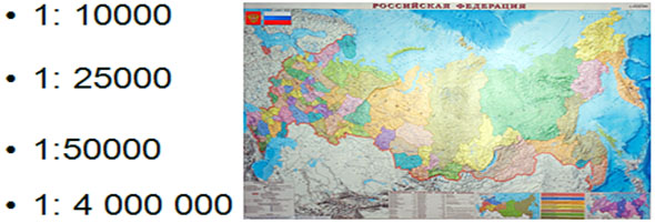
In Russia, for topographic maps, standard numerical scales are accepted:
For special purposes, topographic maps are also created at scales of 1: 5,000 and 1: 2,000.
Main scales topographic plans in Russia are:
1:5000, 1:2000, 1:1000 and 1:500.
However, in land management practice, land use plans are most often drawn up on a scale of 1: 10,000 and 1:25,000, and sometimes 1: 50,000.
When comparing different numerical scales, the smaller one is the one with the larger denominator M, and, conversely, the smaller the denominator M, the larger the scale of the plan or map.
Thus, scale 1:10,000 is larger than scale 1:100,000, and scale 1:50,000 is smaller than scale 1:10,000.
Named Scale
Since the lengths of lines on the ground are usually measured in meters, and on maps and plans - in centimeters, it is convenient to express scales in verbal form, for example:There are 50 meters in one centimeter. This corresponds to a numerical scale of 1: 5000. Since 1 meter is equal to 100 centimeters, the number of terrain meters contained in 1 cm of a map or plan is easily determined by dividing the denominator of the numerical scale by 100.
Linear scale
It is a graph in the form of a straight line segment, divided into equal parts with signed values of the lengths of the terrain lines commensurate with them. The linear scale allows you to measure or build distances on maps and plans without calculations.Scale Accuracy
The limiting possibility of measuring and constructing segments on maps and plans is limited to 0.01 cm. The corresponding number of meters of terrain on the map or plan scale is the ultimate graphic accuracy of this scale. Since the scale accuracy expresses the length of the horizontal laying of the terrain line in meters, then to determine it, the denominator of the numerical scale should be divided by 10,000 (1 m contains 10,000 segments of 0.01 cm each). So, for a map with a scale of 1: 25,000, the scale accuracy is 2.5 m; for map 1: 100,000-10 m, etc.Topographic map scales
| Numerical scale cards | Name cards | 1 cm on the map corresponds on the terrain distance | 1 cm 2 on the map corresponds on the ground area |
| 1: 5 000 1: 1 000 000 | five thousandth ten thousandth twenty-five thousandth fifty thousandth hundred thousandth two hundred thousandth five hundred thousandth, Or half a millionth millionth | 50 m 10 km | 0.25 ha 100 km 2 |
Below are the numerical scales of maps and their corresponding named scales:
Scale 1: 100,000
1 cm on the map - 1000 m (1 km) on the ground
10 cm on the map - 10000 m (10 km) on the ground
Scale 1:10000
1 cm on the map - 100 m (0.1 km) on the ground
10 cm on the map - 1000m (1 km) on the ground
Scale 1:5000
1 cm on the map - 50 m (0.05 km) on the ground
10 cm on the map - 500 m (0.5 km) on the ground
Scale 1:2000
1 cm on the map - 20 m (0.02 km) on the ground
10 cm on the map - 200 m (0.2 km) on the ground
Scale 1:1000
1 cm on the map - 1000cm (10 m) on the ground
10 cm on the map - 100 m on the ground
Scale 1:500
1 cm on the map - 5 m on the ground
10 cm on the map - 50 m on the ground
Scale 1:200
1 cm on the map - 2 m (200 cm) on the ground
10 cm on the map - 20 m (0.2 km) on the ground
Scale 1:100
1 cm on the map - 1 m (100 cm) on the ground
10 cm on the map - 10m (0.01 km) on the ground
Betuganov Astemir
Project Manager:
Shopagova Alla Sergeevna
Institution:
MKOU "Secondary School No. 27", Nalchik
In the presented research work in mathematics on the topic "Scale and its application" I will try to find out at what scale it will be convenient to place objects on A4 sheet. Working on a research project on scale will help me consolidate my knowledge of mathematics.
In my research project in mathematics "Scale and its application", I will need to refine and compare mathematical calculations with the data obtained.
During research work in mathematics about scale and its application, I hope that the scales that I set will allow me to arrange objects on an A4 landscape sheet.
Also, in the practical part of my work, I will consider and mathematically solve interesting problems for distance and scale.
Introduction
Main part
1. Definition of scale.
2. Solving interesting problems on scale.
conclusions
Applications.
Introduction
At the lessons of mathematics in the 6th grade, we went through this interesting topic from which we learned how, using a scale, you can find the distance on the ground, knowing the length of the segment on the map corresponding to this distance on the ground, and vice versa.
When drawing an image of objects on paper, we are most often forced to change their actual dimensions: large objects have to be depicted in a reduced form, and small objects must be enlarged.
Areas of the earth's surface are depicted on paper in a reduced form. An example of such an image is any map, plan. And small details are depicted in the drawings in an enlarged form.
But a drawing, map or plan should give an idea of the real dimensions of objects. Therefore, a special entry is made on the drawings and maps, showing the ratio of the length of the segment on the map or drawing to its real length.
Theme of my research project mathematics " Scale and its application».
Objective of the project: find out at what scale it will be convenient to place objects on A4 sheet.
Project objectives:
- consolidate school knowledge in mathematics;
- clarify whether the mathematical calculations are comparable with the data obtained.
Hypothesis: patterns most effectively draw 1:10, apartment layout 1:100; house passport 1:1000; city map 1:10000; area map 1:100000.
Expected Result: the scales I set will allow you to place objects on the landscape sheet.
Equipment:
ruler, pencil, compass, calculator, map.
sheet A 4, ruler, pencil.
Scale definition
Scale- this is a fraction, where the numerator is one, and the denominator is the number that shows how many times the distance on the terrain is reduced than on the ground.
For example: 1:1000 (one thousandth) means that all distances on the ground are reduced by a thousand times. How more number in the denominator of the fraction, the greater the decrease and the greater the coverage of the territory.

- numerical, expressed in numbers 1:1000;
- named, expressed in words, that is, we translate cm into m: in 1cm 10m, 10m is the scale value;
- linear, knowing the scale value, we can determine the distances.
Let's look at the map. At the top is the scale (1:500,000). The map is said to be drawn to a scale of one five hundred thousandth. This means that 1 cm on the map corresponds to 500,000 cm on the ground. This means that a segment on the map of 1 cm corresponds to a segment on the ground of 5 km.
And if I take a segment 3 cm long on the map, then on the ground it will be a segment 15 km long.
I downloaded a map of the Kabardino-Balkarian Republic from the Internet. Map of the republic with a scale of 1:10000, that is, 1 cm 100 meters, and the scale of the surroundings 1:100000 at 1 cm 1 kilometer. I immediately found my native village on it.
So, the scale (German. Maßstab, lit. " measuring stick»: Mass « measure», Stab « stick”) - in general, the ratio of two linear dimensions.
In many areas practical application scale is the ratio of the size of the image to the size of the depicted object .
The concept of scale is most common in geodesy, cartography and design - the ratio of the natural size of an object to the size of its image.
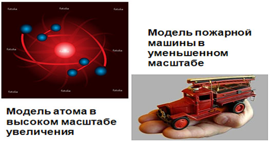
A person is not able to depict large objects, such as a house, in full size, and therefore, when depicting a large object in a drawing, drawing, layout, and so on, a person reduces the size of the object several times: two, five, ten, one hundred, one thousand, and so on times. The number showing how many times the depicted object is reduced is the scale.
The scale is also used when depicting the microworld. Man cannot picture living cell, which is examined in a microscope, in full size and therefore increases the size of its image several times.

The number showing how many times the increase or decrease of a real phenomenon was made when it is depicted, defined as a scale.
Some photographers measure scale as the ratio of the size of an object to the size of its image on paper, screen, or other media.
The correct scaling technique depends on the context in which the image is used.
conclusions
compared their assumptions put forward in my hypothesis with inscriptions on patterns, maps and technical plans of the house and apartment. It turned out that in some places I was wrong 10 and even 100 times.
- patterns most effectively draw 1:10;
- layout of the apartment 1:100;
- house passport 1:1000;
- city map 1:10000;
- area map 1:100000.
In fact, the plan of the apartment is usually taken on a scale of 1:200; the scale of the maps turned out to be exactly the same as in the original, but they are already located on 6 landscape sheets!
So once again, I am convinced that before assuming, you need to recalculate several times.
In this way, we formed the concept of scale, map, drawing, worked out solving problems for calculating the length of a segment on the ground and on the map.
Solving problems on a scale
Task 1. The distance between the two cities is 400 km. Find the length of the segment connecting these cities on a map drawn at a scale of 1:5000000.
Solution:
400km = 400000m = 40000000cm
40000000: 5000000 = 40: 5 = 8 (cm)
Task 2. Distance from Moscow to St. Petersburg in a straight line is approximately 635 km from center to center. On the highway, the length of the route is 700 km.
By how many times should this distance be reduced so that it can be depicted on a slide as a segment 14 cm long?
Solution:
700km = 700000m = 70000000cm
70000000cm: 14cm=5000000(times)